BWI NextGen Pre/Mid/Post METROPLEX
Uncovering the facts about BWI NextGen Pre, Mid and post Metroplex changeovers. Published: 8/12/17 Updated: 3/2/19
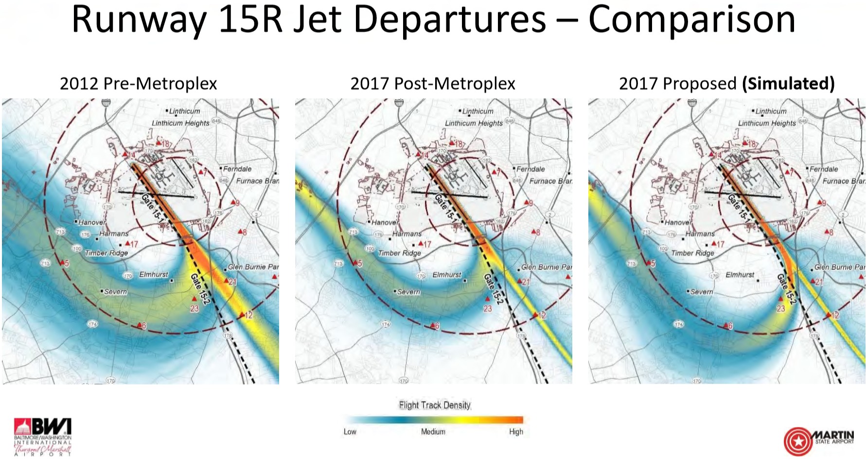
The above images are RWY 15R jet path comparisons: 1) Pre-Metroplex (Pre-NextGen) image. 2) Post-Metroplex image (also known as NextGen 2nd rollout) and the 2017 proposal image that is supposed to get the path back to Pre-Metroplex (Pre-NextGen). This 2017 proposed simulation does not even come close to resembling the Pre-Metroplex image path. The BWI images above do not include the initial NextGen stage called: Metroplex or (NextGen 1), which is discussed further down. As of (2/26/19) the 2017 path change proposal (above right) has yet to be implemented. In its current form, this proposal is not an acceptable change because it moves traffic off one community and onto many other communities. In order to be fair, the path change proposal needs to resemble the Pre-Metroplex (Pre-NextGen) wide path, as discussed at the BWI Roundtable meetings. BWI Online Complaint Form Link
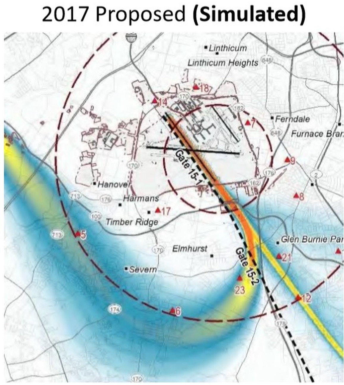
Enlarged BWI RWY15R (path change proposal image) above. Added 2/26/19 BWI Online Complaint Form Link
From what we have been shown and told so far, it seems the FAA does not know (or has not figured out) how to accomplish the task of duplicating the wide dispersion path of Pre NextGen. The problem is said to be caused by the newly implemented (2015) NextGen-Metroplex Satellite Based Navigation system and other new NextGen navigational changes that are said not to be easily adaptable to wide path procedures?
I believe there is a relatively easy way (formula) to solve the NextGen narrowed path issue. For example: Starting with 10 initial way-points (navigation markers) approximately 1 mile apart for incoming jets flying over (for this example) an area like Arnold, Severna Park, Pasadena and Millersville. The first incoming jet would be systematically assigned to way point #1; the next jet would be assigned a mile away to the next way point #2; then another jet a mile away to way point #3 and so on up the line to way point #10. On the next rotation, the jets would be assigned a split path between each way point in the same order #1 thru #10 as before. And, on the next rotation, the jets would again, be assigned a different split path between each way point #1 thru #10. There would be 3 split paths (A,B and C) between each way point, which creates 4 paths total per way point at 1/4 mile apart. (Jets paths will always be 1 mile apart from the previous jet path during the rotation and splits). Once the initial way point rotation followed by the split rotations are completed, the way point rotation will start all over again with way point #1, #2, #3... thru #10, followed by the split rotations #1A, #2A, #3A... thru #10A and so on to #1B, #2B, #3B... thru #10B, then to #1C, #2C, #3C... thru #10C. A special navigation software program would be designed to automate and assist air traffic controllers with this task.
How would the above formula affect residents? For this example: Residents in Arnold, Severna Park, Pasadena and Millersville, assuming jets are coming in at a rate of 1 jet every two minutes. At that rate, on the first way point rotation, a resident would hear only 1 jet fly overhead, then approximately 20 min. later, you may notice another jet 1/4 mile away. Then, approximately 20 min. later you may or may not notice another jet 1/2 mile away, that will be the last jet you hear for approximately 1.2 hours (of peace) as the way point rotation continues to completion, at which time the way point rotation begins all over again.
This formula will also work for outgoing jet departures. Outgoing jets departing (for example) RWY 28 west out Columbia and RWY 15R over Severn would (for example) have 5 initial way points and use the above formula to achieve dispersion.
The webpage below discusses and tells the story of how the initial circa 2015 NextGen Mid Metroplex path change, first called "NextGen Metroplex" and the later circa 2016 NextGen Post Metroplex path change
to BWI runway 15R have unfairly and adversely affected some of the communities near BWI airport to the present day (3/10/19). Suggestions
to alleviate the problems are discussed below:
Community streets; main roads and names were overlaid onto the 3 cropped FAA images below because the original FAA images lacked map features to help identify communities and locations. NOTE: The FAA made the yellow jet tracks thicker than the blue
and red jet tracks in the images further down, giving the appearance of more jet
traffic; however, all images have approximately the same amount of jet
traffic. The yellow jet tracks image traffic should look sparser compared to the blue and red tracks images. Please keep this in mind when comparing.
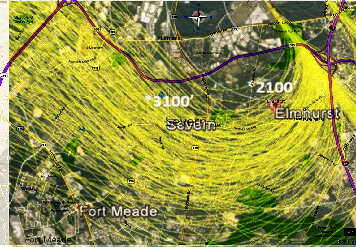
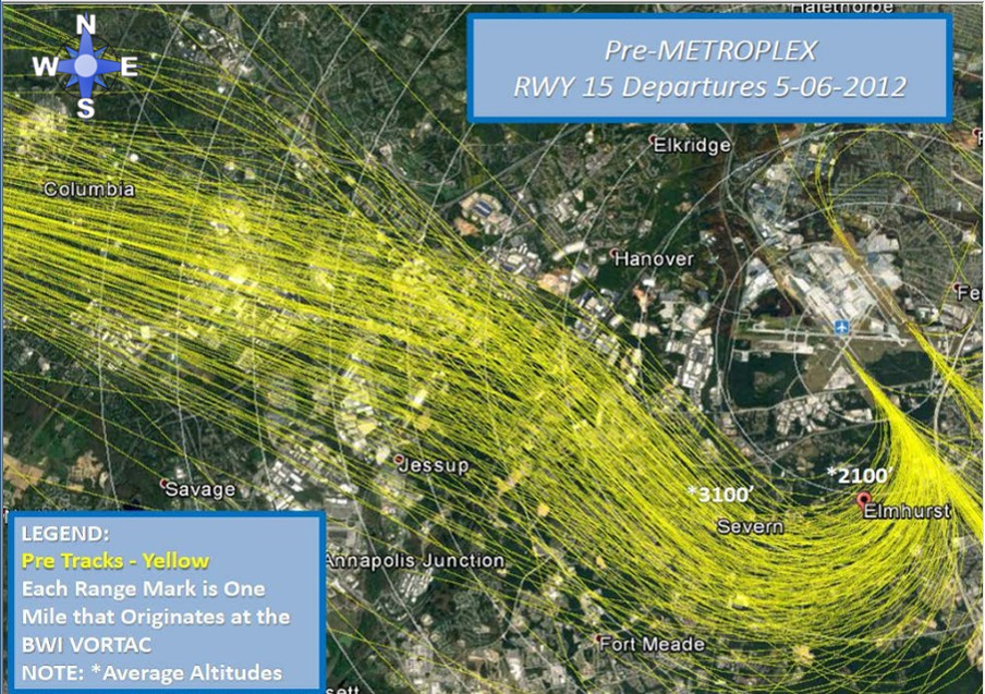
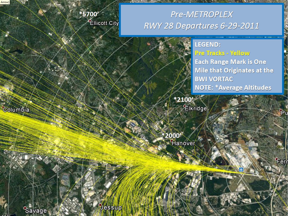
BELOW: BWI runway 15R Pre NextGen (yellow tracks image) showing jet departures over a 24 hour period circa 2012. Pre NextGen also called (Pre Metroplex) procedures were in place since the 1990`s up to spring 2015. Notice
the jet tracks are well dispersed over a wide area, which lessens fly over repetition. Pre NextGen jets began turning west at a distance of one
mile after DME (Distance Measuring Equipment).
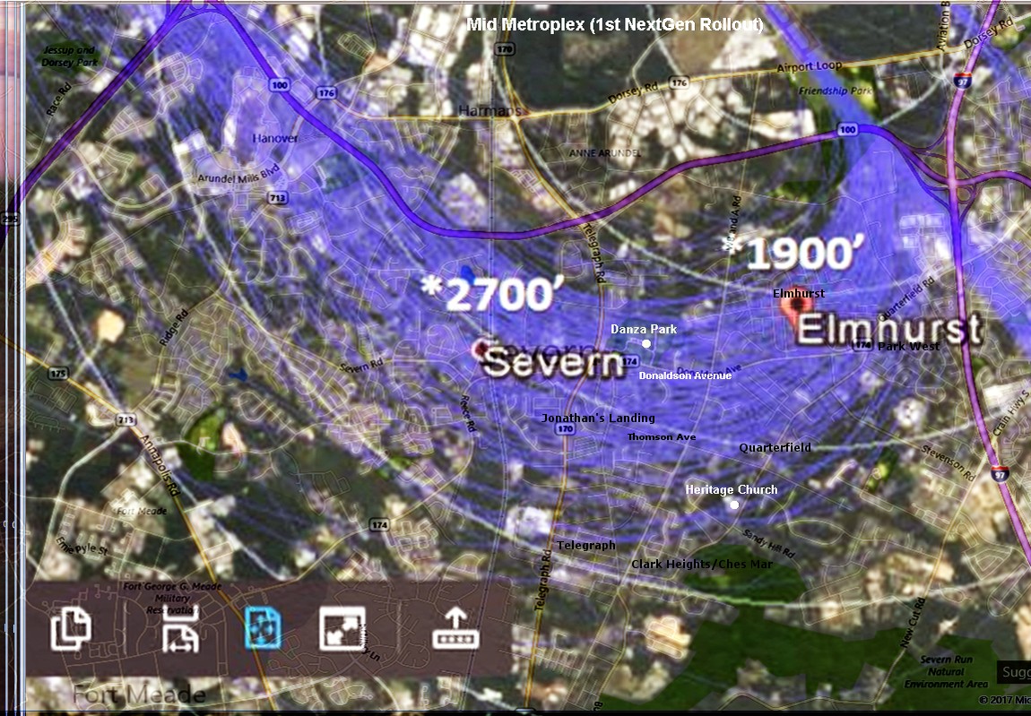
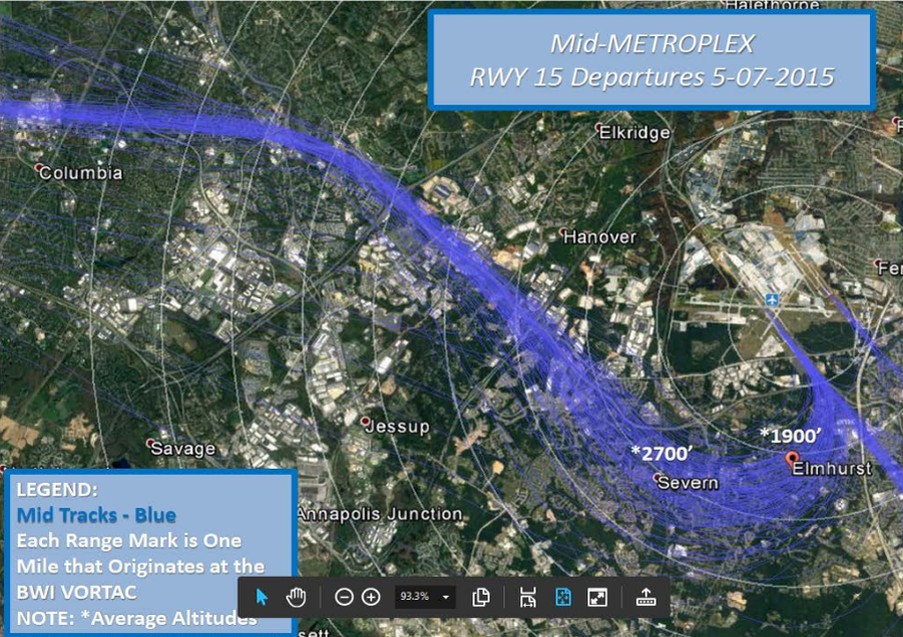
The NextGen Mid Metroplex 1st roll-out, (originally just called "NextGen Metroplex" introduced spring 2015) blue tracks image below, was supposed to be the only
NextGen roll-out. Mid Metroplex narrowed down the existing flight path dramatically,
concentrating the air traffic, resulting in increased repetition and noise for all communities under it`s narrowed path. Among the affected communities was Elmhurst, whose jet traffic increased dramatically from NextGen. Some Elmhurst residents understandably complained about the unfair increase in noise, this article discusses how the FAA responded to their complaints and shows the differing NextGen changes .
Below: NextGen 1st rollout, originally called (NextGen Metroplex), now called (Mid Metroplex), jets began turning west at an altitude of 667
feet. The altitude jets begin to turn west is not the altitude they will be at when flying over communities, the jets are much higher by the time they reach any communities. The turn altitude dictates the overall position of the jets flight path, lighter jets reach the turn altitude sooner than heavier jets, that explains why the jets are spread out within the path. The heavier jets reach the turn altitude later and are the ones going out the farthest into the area communities while turning west. (The distance between each white ring is 1 mile.)
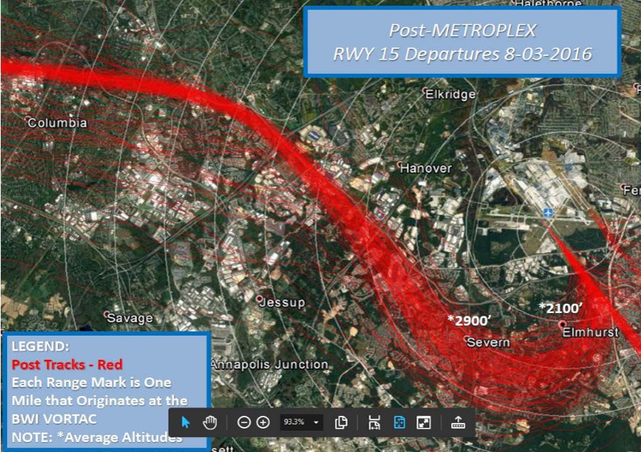
Some Elmhurst community residents understandably complained about the unfair increase in jet traffic from NextGen, in response (in 2016 after the runway construction was completed) the FAA changed runway 15R departure procedure. Instead of going back to Pre NextGen (wide spread path) procedures, the FAA introduced the "Post Metroplex" second roll-out, (so-called, seemingly to make it appear like it was part of the original NextGen plan), which it was not. The Post Metroplex change (red tracks image below, circa 2016) revised RWY 15R departure procedure to require aircraft to begin turning west at 850 feet (previously 667 feet). This resulted in plane paths shifting 1/2 mile south, reducing air traffic over much of Elmhurst to Pre NextGen levels, while at the same time, shifting the concentrated narrowed path jet traffic over the adjacent communities of Park West; Quarterfield; Quarterfield Farms; Brookwood Run; Clark Heights/Chesmar; Clark Station Rd/Illinois Ave; Telegraph and many other communities, adversely affecting more people. (Over 44,000 people live in Severn area communities, according to the 2010 census).
Compare the blue tracks image above to the red tracks image below, after studying the two images, you can see the jet traffic was shifted off of Elmhurst and onto Park West; Quarterfield; etc. It is evident that the FAA (Post Metroplex) path shift is unfair and unjust because it shifts the NextGen narrow path jet noise burden from one community to another community rather than spreading out the jet traffic among ALL of these communities, like it was with before NextGen. (If the FAA had gone back to Pre NextGen (wide spread path) procedures there wouldn't be an issue, but they didn't). Meanwhile, the FAA touted the (Post Metroplex) path shift as "addressing community concerns"; however, shifting the noise burden from one community to another community is unfair. Many communities affected by the (Post Metroplex) path shift existed long before BWI airport was built, e.g. Telegraph, Clark Station and Quarterfield. (BWI Airport commissioned in 1950, predates the Elmhurst community by approximately 15 years).
BWI Online Complaint Form Link
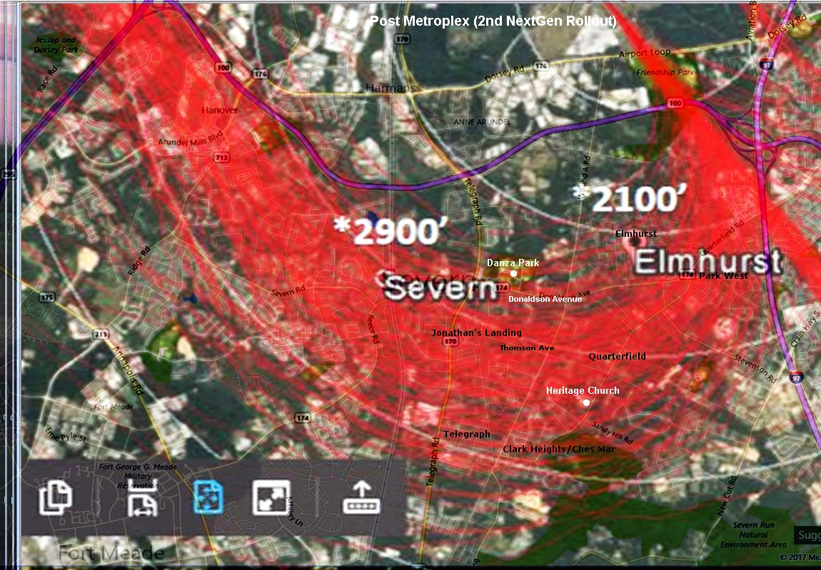
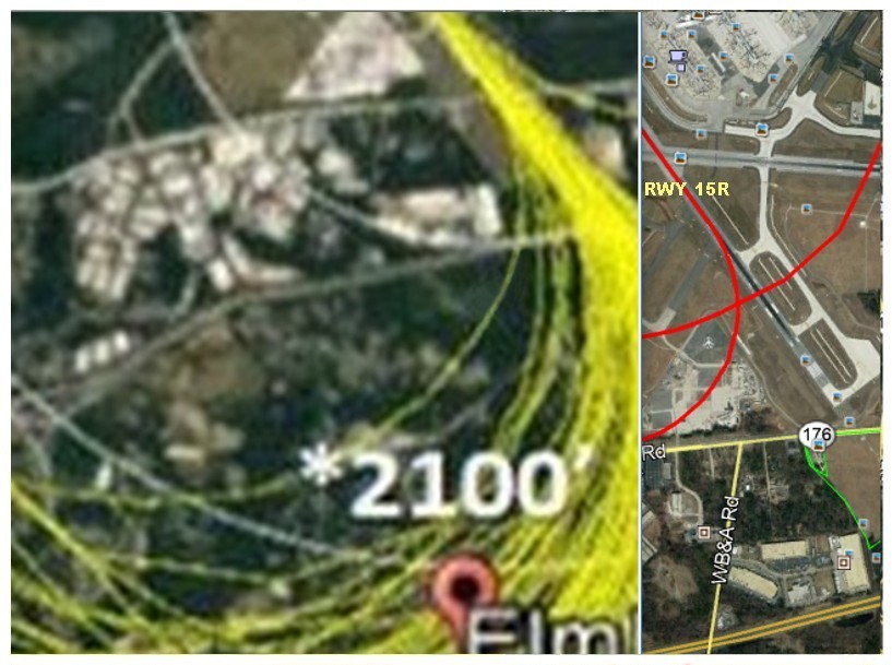
Note that the FAA prominently displayed Elmhurst in all three of the FAA images, why? Elmhurst is not a city, it is a neighborhood. If you map search for Elmhurst, you`ll get zero local results. Notice the map location placemark symbol for Elmhurst is different, it is larger and more emphasized than all other areas named on the map below, meaning it was placed there. To me, this says: "See Elmhurst, we reduced your air traffic." (It was revealed at the 7/18/17 BWI Community Roundtable meeting that noise complaints from (some) Elmhurst residents were the incentive for the Post Metroplex path shift change.)
Elmhurst is not responsible for the Post Metroplex path shift change, Elmhurst had no control over how the FAA would respond to their complaints. I blame the FAA for increasing the air traffic over Elmhurst with NextGen Metroplex, distressing them and when they complained enough, the FAA just shifted the oppressive, concentrated NextGen air traffic over neighboring communities and calling it (Post Metroplex) and touting this sneaky maneuver as being a helpful procedure change. The only fair solution would have been to go back to Pre Metroplex wide path procedures.
So
why didn`t the FAA go back to Pre NextGen wide path procedures in the
first place, instead of doing the unfair Post Metroplex path shift? The reason given, according to the FAA, is the newly implemented NextGen-Metroplex (Satellite Based Navigation) system, as well as other NextGen-Metroplex associated navigational changes are said to not easily allow the duplication of the Pre NextGen path.
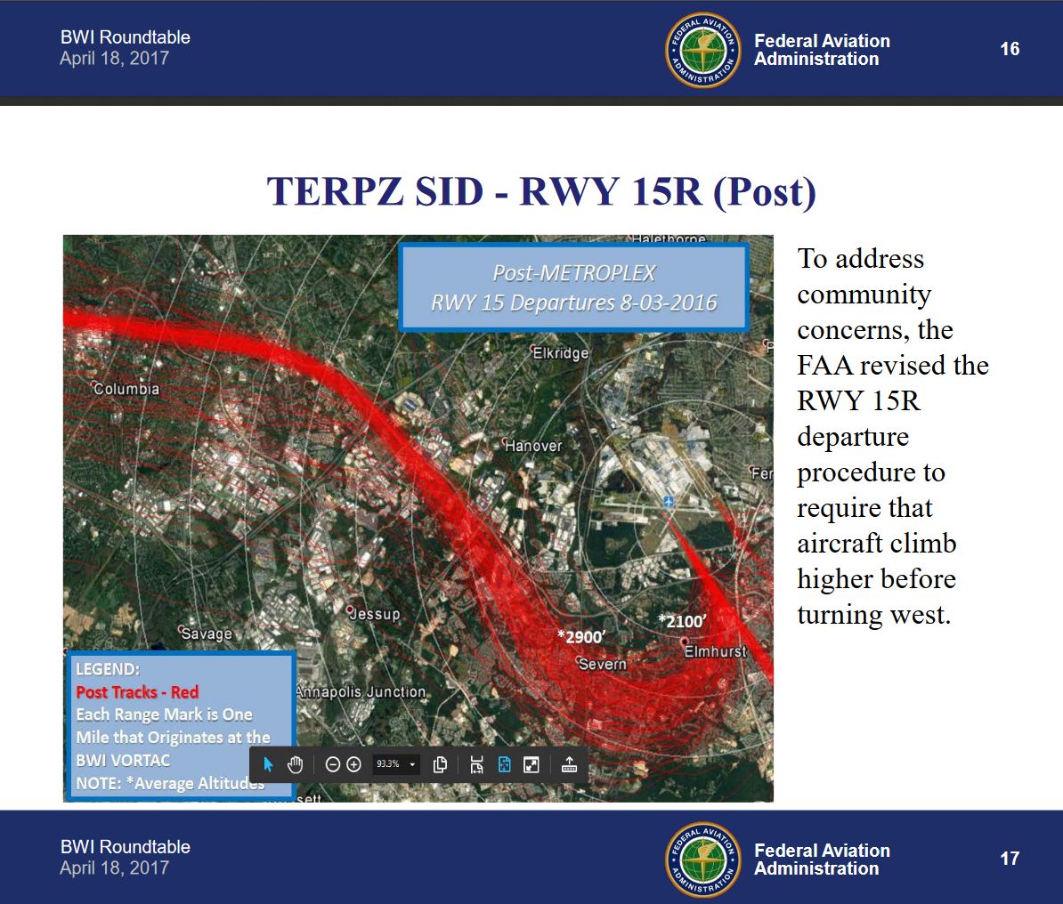
The image above: Is the original un-cropped image which shows the
caption ("To address community concerns"). As shown at the 4/18/17 BWI
Community Roundtable meeting. The community the caption is referring to
is Elmhurst, depicted with a unique map location
placemark symbol (not the entire
Severn community, as the caption would seem to suggest). In summary,
moving jet traffic from one area of communities to another area of communities, because they were asked
to, gives the appearance of favoritism. BWI Online Complaint Form Link
*Update
5/22/18: At recent Roundtable meetings the FAA has indicated they are
going to try implementing new departure procedures intended to try to
duplicate Pre NextGen wide dispersion flight paths for jets departing
from runway 15R. The BWI Community Roundtable has asked the FAA to
provide charts to show how the new FAA proposed paths would compare to
current paths before implementing the changes.
(7/10/18: The preceding update is now on hold until further notice pending litigation.)
Severn residents were not informed about the Post Metroplex path shift change until many months after it was implemented, at an FAA open house event on 10/17/2016. I attended the open house and studied the three presentation boards that depicted each stage of NextGen departure changes for RWY 15R: Board #1. (Pre NextGen), Board #2. (NextGen Mid Metroplex) and Board #3. (NextGen Post Metroplex path shift). The presentation boards had very little information about the changes. I wanted to know more details because the (Post Metroplex) change appeared to have a negative impact on many communities, while at the same time appearing to help other communities. So I asked the attending Air Traffic Official about the (Post Metroplex) 1/2 mile path shift and he told me "it addressed concerns about where (Mid Metroplex) RWY 15R jets begin turning west, the path shift supposedly addressed these concerns". I got the impression the Air Traffic Official was not giving me the whole story. I didn't buy that the FAA was making a correction with Post Metroplex, because after studying the two paths, it is obvious the point where the jets begin to turn west (given the 2x increase in jet traffic due to the "new" narrowed path) is identical in both "Pre Metroplex" and "Mid Metroplex" paths. And when looking at the Post Metroplex path , it is obvious a certain area is favored. For this reason, I continued to investigate and study over the past three years to uncover the truth and have posted what I learned on this webpage.
What else can be done to reduce jet noise? There is technology being developed that could be employed by airports that could greatly increase the altitude of departing jets flying over communities. The U.S. Navy is developing the use of Electromagnetic Aircraft Launch Assist Systems with the construction of the Gerald R. Ford class aircraft carrier. Linear induction Motor (LIM) and Linear Synchronous Motor (LSM) technology uses electromagnets, which utilize electricity to help propel/accelerate the aircraft on the runway to much higher speeds, allowing for greater initial altitudes. This technology could possibly one day be applied to airport runways and could help jets achieve much higher initial altitudes without increasing noise. This concept is similar to the steam catapult used on aircraft carriers, but uses electricity and electricity can apply thrust smoothly and comfortably, to assist departing jets achieve higher initial altitudes. This could help make future airport growth more palatable to people living near airports. I believe Linear Induction Motor (LIM) technology should be presented to the FAA/MAA for study. An additional idea to decrease departure noise from RWY 15R, is discussed further down, titled: NOISE ABATEMENT.
A word about incoming jet traffic: The obvious answer to "NextGen" air traffic flying at low altitude over Millersville; Severna Park; Pasadena
and other communities on their way to land at runway 33L is to create
multiple incoming paths (way points) and rotate the paths to simulate
Pre-NextGen paths. Also, jets should try to maintain higher altitudes
for as long as safely possible, then employ a steeper decent closer to
the airport. This (should) be easy to accomplish with today`s
technology and has been suggested at most every Roundtable meeting since
the beginning by multiple Roundtable members.
Your complaints to BWI will help affect future decisions concerning airport procedure.
To view the complaint form on your smartphone, turn it on it`s side.
BWI Online Noise Complaint Form Link
NextGen/Metroplex Detailed Information Link
Full area images below, from which the three cropped images above were made, these were shown at the the 4/18/17 BWI Community Roundtable meeting. The FAA made the yellow jet tracks thicker than the blue and red tracks images below it, giving the impression of more traffic. However, all images have approximately the same amount of traffic. Pre NextGen image below. (compass added)
Mid-Metroplex NextGen 1
Post-Metroplex NextGen 2
BWI Airport commissioned 1950, first named Friendship International
Airport, changed to Baltimore Washington International (BWI) in 1973.
A word about BWI Airport procedure during calm wind periods:
In the summer of 2017 many residents south of BWI in close proximity (< 4 mi) to
the airport noticed more RWY 15R jet departures during calm
wind periods than in the past. For example, in the Summer 2016 there were
extended periods of **relative peace (no 15R air traffic) because the
preferred runway, 28 west, was used for departing jets during calm
periods; however, that has not been the case this year (2017). An unusually
high amount of departing jet traffic is using runway 15R when winds are
calm. (The following is based on how I recalled the following event.)
At The BWI Community Roundtable meeting 7/18/2017, there was an FAA
representative and an air traffic control representative present while
two of the Community Roundtable members appeared to be actively trying
to persuade the FAA representative and air traffic control
representative to change airport procedures concerning preferred runway
take-off procedure during calm wind periods (by voicing their discontent
with it). They lobbied to have the 15R southeastern departure runway
used during calm wind periods. Both officials appeared to resist the
efforts of the Roundtable members, but the very next morning, 7/19/2017
at 5:20 am, Jets were departing from runway 15R east instead of from
runway 28 west as normal calm wind procedure would have called for. At
that time, the documented winds were calm (0 mph with gusts from the
west up to 3 mph). As a result, many communities (< 4 mi) south of
BWI were awakened by 15R jets turning over them to go west. I was told
the two Roundtable members were unaware of the negative impact changing
Calm Wind Procedure would have on other communities. (Update:
on 8/24/2017, a Roundtable member informed me that: " the Calm Wind
Procedure adjustment/change is off the table and no longer being
considered because it just shifts the burden from one community to
another." Just like the NextGen Mid to Post Metroplex path shift did.) It remains to be seen if the BWI control tower will follow Calm Wind Procedure. (Update: 10/1/17, the control tower has been following procedure (for the most part) for the past three weeks, bravo!)
Update:
12/22/17, the control tower has reverted back to ignoring "Calm Wind
Procedure" . (Update: 1/04/18, after sending two letters to BWI
officials the BWI control tower has been following "Calm Wind Procedure"
for the past week or so. Update: 4/15/18, the control tower has been
following "Calm Wind Procedure".
**NOTE: Many communities south of BWI also get runway 28 departure traffic going east flying overhead, but at
higher altitude so the noise is marginally less obtrusive than than
runway 15R departure traffic.
Preferred Runway Operation Mode (Calm Wind Procedure) explained:
When winds are above
approximately 5 mph, the airport chooses the departure runway based on
the direction of the prevailing winds. If the winds are coming from the
west, for example, the airport will use runway 28 west, which has a western
heading for jets taking off. When the wind is coming from the east, the
airport will use runway 15R which has a southeast heading. However,
when the winds are calm (approximately 5 miles an hour or less),
the preferred runway for departing flights is runway 28 heading west (28 west is the primary departure RWY).
This means that if the winds are at 5 mph or below the airport prefers
to use runway 28 west for departing flights. The 28 west preferred
departure mode procedure is
based on airport design.
Note: BWI may use any runway at their discretion based on maintenance etc...
Many communities south of BWI have sort of a double edged sword with
regard to BWI airport. We get air traffic no matter which
runway is in use powering over
top of our communities to gain altitude day in and day out. The most
obtrusive air traffic is from runway
15R turning right to go west. Additionally, we get east flow traffic
from runway 28 making a U turn over us to get to eastern cities, such as
New York, Boston etc... Jets taking off and climbing to gain altitude
are far more noisy than incoming jets on their way to land.
Your complaints to BWI will help affect future decisions concerning airport procedure.
To view the complaint form on your smartphone, turn it on it`s side.
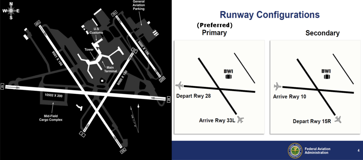
BWI RUNWAY LAYOUT AND FUNCTION: The primary departure runway is 28 west and the primary arrival runway is 33L north. The secondary departure runway is 15R east and the secondary arrival runway is 10 east. (Historically, the primary departure runway 28 west is used about 70% of the time and the secondary departure runway 15R east is used about 30% of the time). The deciding factor for which runway is in use is mainly governed by wind direction and wind speed .
RWY 28 Post-Metroplex NextGen 2 (current departure tracks)

RWY 28 east bound jets circle back over us at somewhat higher altitude compared to RWY 15R departures.
RWY 28 Pre-NextGen departure tracks
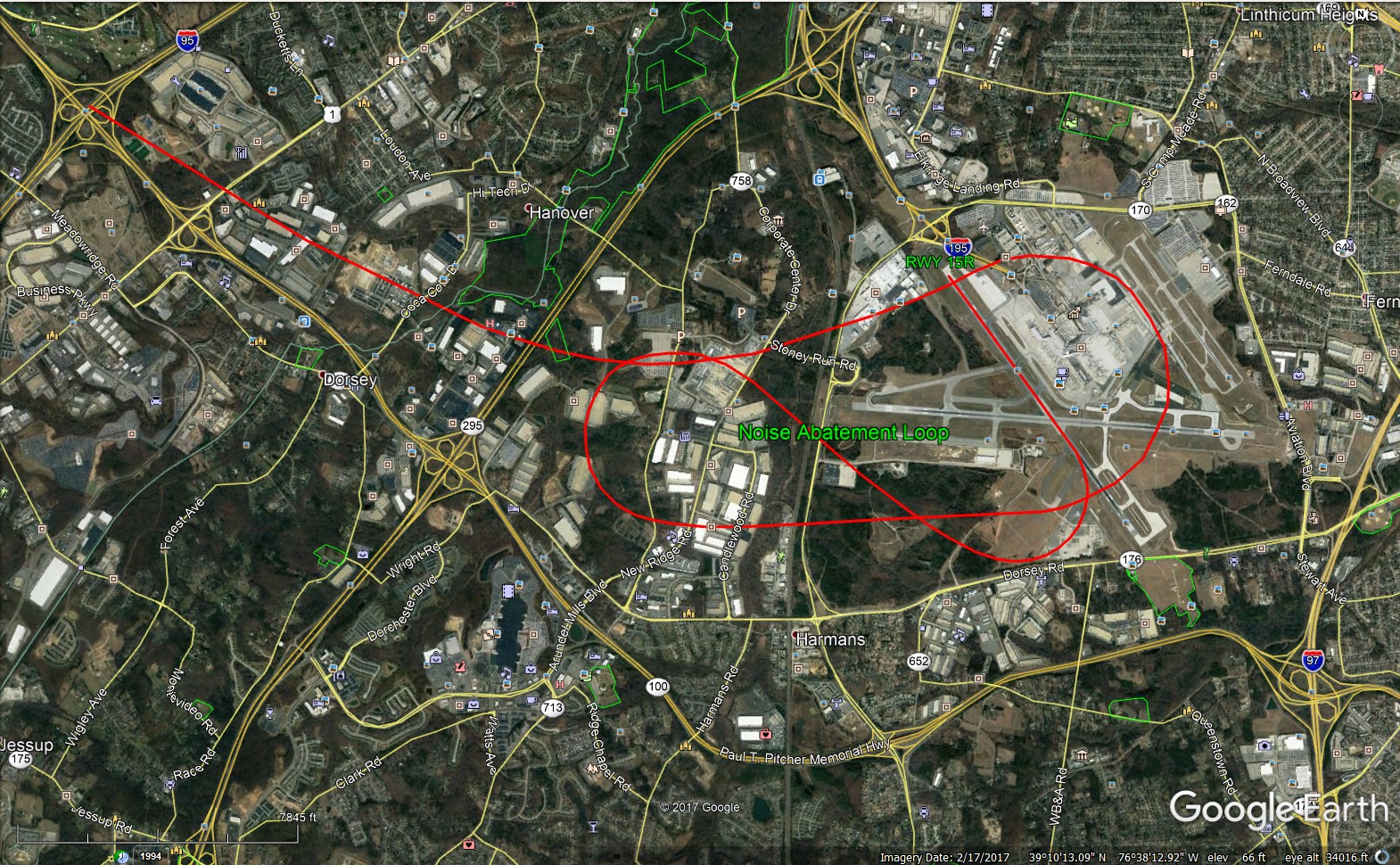
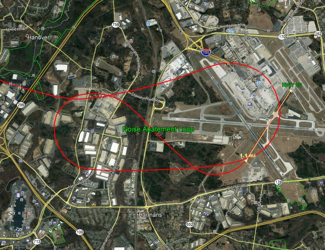
NOISE ABATEMENT: We considered presenting the idea of using RWY 22 to help reduce the
impact of RWY 15R east flow turning to go west; however, RWY 22 has been permanently closed down and partially dismantled, requiring a lot of work (and political action) to re-open. Additionally, after studying RWY 15R departures, we noted that most jets are airborne by mid-track, which would appear to allow them to easily follow the Noise-Abatement-Loop (idea). The loop idea would allow jets to gain altitude over non-residential areas, instead of over us. This idea is very unusual, but it appears to be possible and we should explore all possibilities. We have shared this idea with a District 32 Roundtable member and he is curious to know if this Noise-Abatement-Loop (idea) is possible to employ. This idea will be presented at the next Roundtable meeting. (We presented the loop idea to an air traffic official at the 11/7/17 Roundtable
meeting and he said: "the idea was very interesting and he appeared intrigued; however, he noted that jets are currently not allowed to begin turning until reaching an altitude of about 500
feet, which is the point they become visible to the FAA tracking systems." The Noise Abatement Loop turn altitude would start at about 125 ft, which does not conform to the current rules. The conversation ended at that point.) Obviously, many procedure adjustments and variances would be required for this idea to work. We are contemplating further discussion on the feasibility of the Noise Abatement Loop idea.
Noise Abatement loop (Idea) Applied to RWY 15R
The 2010 census indicates over 44,000 people live in the Severn area between Interstate 97 and 295. The Noise Abatement Loop may allow jets to gain altitude over non-residential areas, instead of over us.
RWY 15R Noise Abatement Loop (Terrain View)
Most jets taking off from RWY 15R are airborne by mid-runway.
Noise Abatement Loop Turn Diameters
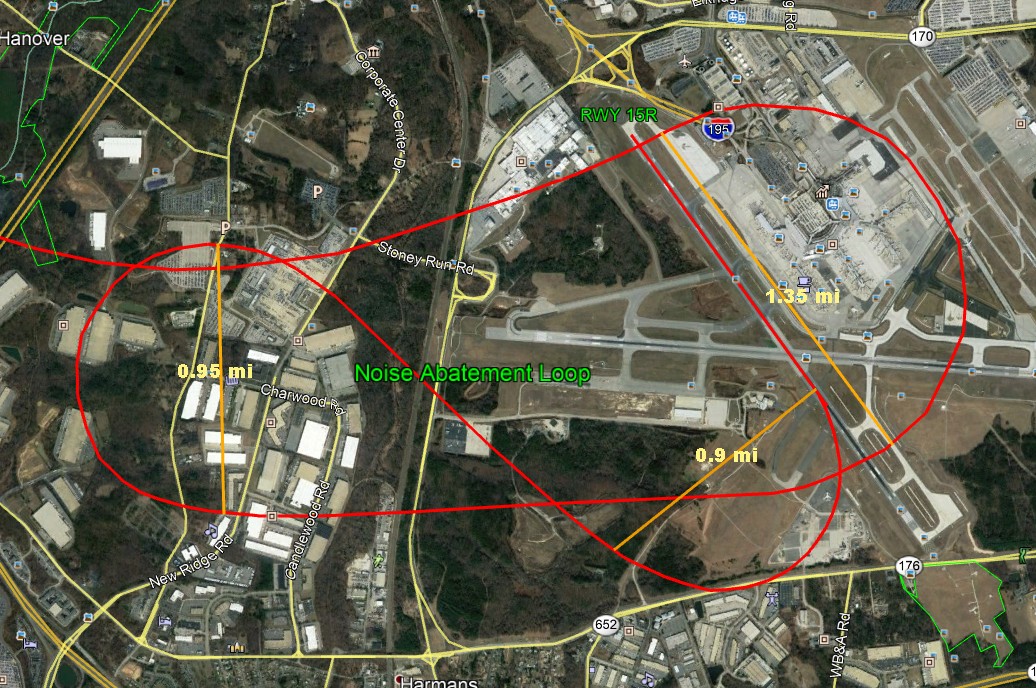
0.9 mi turn diameter would require turn speed of 165 mph at 37.5 degree bank angle.
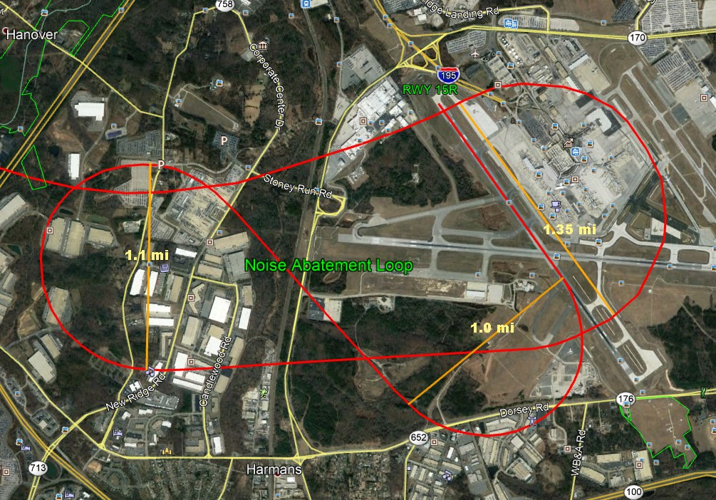
1.0 mi turn dimeter would allow turn speed of 175 mph at 37.5 degree bank angle.
Most Jets Airborne Mid-Runway
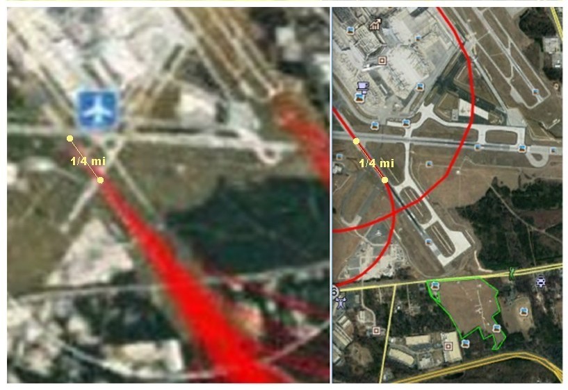
(Above) Jets become airborne at mid-runway (NextGen2 image left) allowing 1/4 mile to gain altitude before loop turn begins.
RWY 15R turn angle comparison (Pre-NextGen vs Loop turn)
Both paths initial turn angles are similar.
RWY 28 - 22 - 15R west flow track distance comparison to I95
Although we are now focusing primarily on RWY 15R for possible noise abatement ideas, an interesting fact about RWY 4/22 is that on (December 08, 2011) BWI closed runways 10/28 and 15R/33L at the same time and used runway 4/22 for all flight operations. I mention this to answer those who have asked whether RWY 4/22 was capable of handling larger planes and the answer appears to be yes.
Link to article: BWI uses RWY 22 for all flight operations while the two main runways are closed for maintenance.
Noise Abatement Loop applied to RWY 22
RWY 22 is (was) 1.1 miles long
BWI NextGen Noise - Contact Form
0
0
1
8
2
3